
Earthquakes Shook This Volcano Island for Days. Then It Joined the Mainland.
In January 1914, after hundreds of warning earthquakes shook Kagoshima Bay, Japan's Sakurajima stratovolcano unleashed the most violent volcanic eruption in twentieth-century Japanese history. The cataclysm culminated in a magnitude 7.0 earthquake, a subterranean collapse of the Aira caldera, and an unstoppable three-billion-ton flood of basaltic lava that completely choked the Seto Strait, welding the island permanently to the Ōsumi Peninsula of Kyushu.

In this dossier (9 chapters) ▾
- 01 The Sleeping Giant of Kagoshima Bay
- 02 The Shaking Earth and the Flawed Forecast
- 03 The Double Rupture: January 12, 1914
- 04 The Catastrophic Quake of 6:29 PM
- 05 The River of Fire That Welded an Island
- 06 The Kurokami Torii Gate and the Geological Legacy
- 07 What the Record Shows
- 08 Archival Evidence & Picture Credits
- 09 Verified Archival Sources & Bibliography
Historical Dossier: The 1914 Taishō Eruption of Mount Sakurajima Location: Kagoshima Bay, Kyushu, Japan | Date: January 10 – February 1914 | Key Figures: Dr. Fusakichi Omori, Mayor of Kagoshima, 22,000 Island Evacuees
The Sleeping Giant of Kagoshima Bay
Rising dramatically out of the azure waters of Kagoshima Bay (Kinkō Bay) on the southern tip of Kyushu, Sakurajima had stood as an isolated, conical volcanic island for over ten thousand years. Towering over 3,600 feet, the stratovolcano’s lush, terraced citrus orchards and smoking summit formed one of the most picturesque natural panoramas in East Asia, earning the bay its title as the “Naples of the Orient.”
Separating the island from the bustling merchant city of Kagoshima to the west was a deep, four-mile saltwater sound. To the east, between the island and the rugged mainland cliffs of the Ōsumi Peninsula, lay the Seto Strait—a navigable marine channel 1,300 feet wide and nearly 240 feet deep through which ocean tides surged.
For over a century, Sakurajima had rested in relative slumber. The last cataclysmic explosion had occurred in 1779 during the An’ei era. Over twenty-two thousand farmers and fishermen lived peacefully in eighteen coastal villages dotting the island’s shores, harvesting the world’s largest radishes (Sakurajima daikon) and small sweet mandarins from the fertile volcanic soil.
In early January 1914, during the second year of the Taishō era, that century-old tranquility abruptly unraveled.
The Shaking Earth and the Flawed Forecast
Beginning on Saturday, January 10, the ground under Kagoshima Bay began to shudder. At first, residents felt mild, rhythmic tremors. But by Sunday, January 11, the seismological activity turned terrifying: seismographs at the Kagoshima Meteorological Observatory recorded 417 distinct earthquakes in twenty-four hours, sixty-six of which were violent enough to crack stone masonry in the city.
Across the island, the natural environment showed unmistakable signs of imminent disaster:
- Thermal hot springs suddenly boiled dry or surged violently with scalding, sulfuric mud.
- Deep underground roaring like distant artillery rattled farmhouse foundations.
- Well-water levels across coastal villages dropped precipitously or turned milky white with dissolved gases.
Terrified villagers gathered on the beaches, begging local boatmen to ferry them across the bay. However, officials at the local meteorological observatory, relying on conventional theories, issued public assurances that the earthquakes were tectonic rather than volcanic, advising citizens not to panic.
Fortunately, the islanders trusted their ancestral instincts over modern bureaucracy. Knowing the folklore of the 1779 eruption, village chiefs commandeered fishing sampans, cargo scows, and rowboats. Throughout the night of January 11 and into the early morning of January 12, an armada of small wooden boats ferried over twenty thousand men, women, and children across the waters to safety on the mainland. It was one of the most successful spontaneous civilian evacuations in Japanese history.
The Double Rupture: January 12, 1914
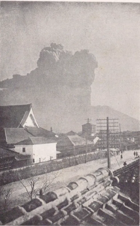
At precisely 10:05 AM on Monday, January 12, the western shoulder of Sakurajima ruptured with an earth-shattering detonation.
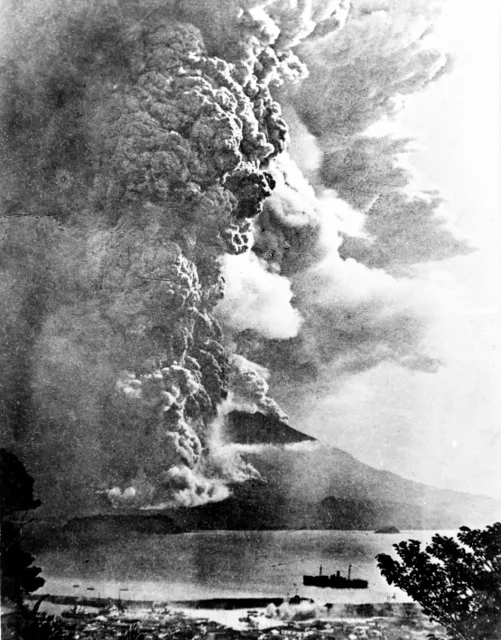
A blinding jet of superheated gas, pulverised pumice, and incandescent volcanic bombs rocketed into the sky. Ten minutes later, at 10:15 AM, the opposite eastern flank burst open above the village of Kurokami.
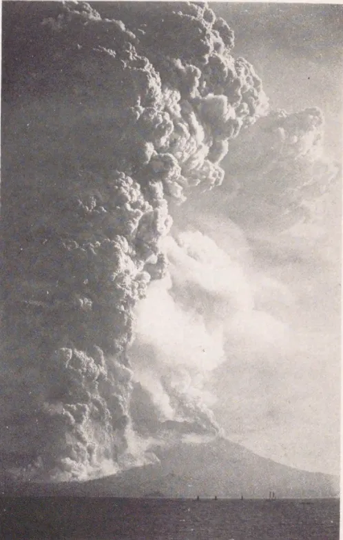
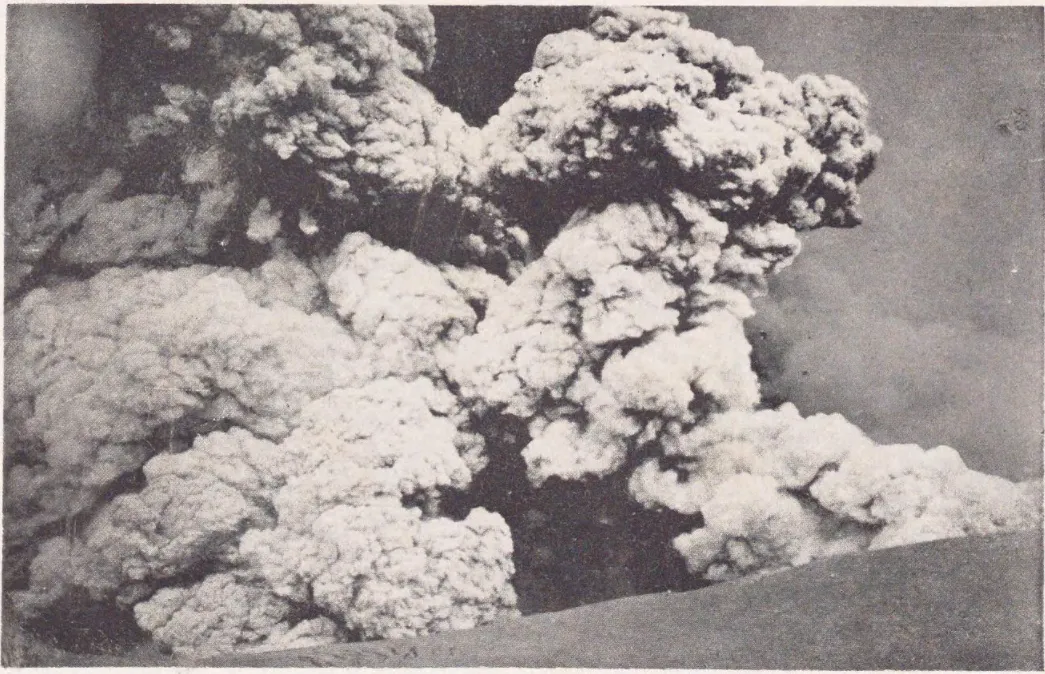
Within thirty minutes, the two eruptive columns merged into a monstrous Plinian ash cloud surging over 26,000 feet (8,000 meters) into the stratosphere.
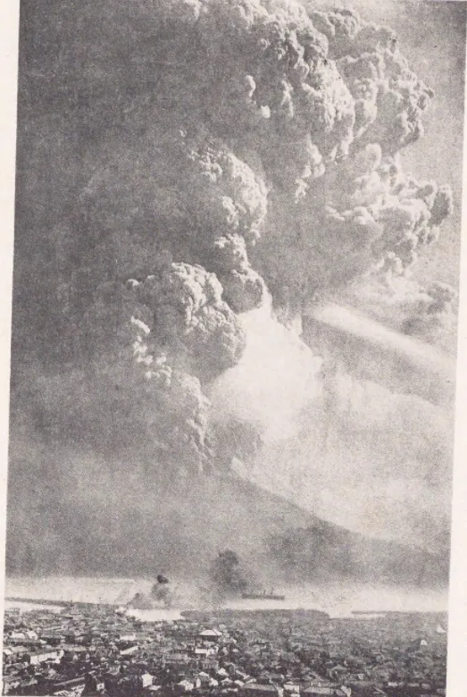
The midday sun was extinguished. A swirling vortex of pitch-black ash, sulfuric acid rain, and roaring pyroclastic lightning plunged Kagoshima Bay into terrifying, unnatural midnight. In Kagoshima City, suffocating ash fell like heavy winter snow, collapsing wooden roofs and forcing ninety thousand urban residents to flee into the countryside.
The Catastrophic Quake of 6:29 PM
The nightmare deepened at 6:29 PM that evening.
As magma chambers deep beneath the bay depressurized, a massive tectonic fracture ruptured directly under the Kagoshima channel, triggering a magnitude 7.0 (or 7.1) earthquake.
The shockwave was catastrophic:
- Hundreds of buildings in Kagoshima City that had withstood the ashfall collapsed into rubble.
- Landslides roared down surrounding mountains, burying roads and railway tracks.
- A sudden tsunami wave surged through the bay, smashing harbor wharves and capsizing rescue boats.
- Thirty-five people perished in the earthquake and ensuing landslides, while dozens more were injured.
Yet the primary geological drama was only just beginning.
The River of Fire That Welded an Island
On the morning of January 13, the explosive pyroclastic phase transitioned into a colossal effusive eruption.
From the Nabeyama vents on the volcano’s eastern shoulder, a glowing incandescent river of thick basaltic-andesite lava began pouring down the slopes. Moving at several yards per hour, the glowing wall of molten rock was over one hundred feet high, incinerating cedar forests, obliterating agricultural fields, and consuming every building in its path.
The lava front marched relentlessly toward the Seto Strait.
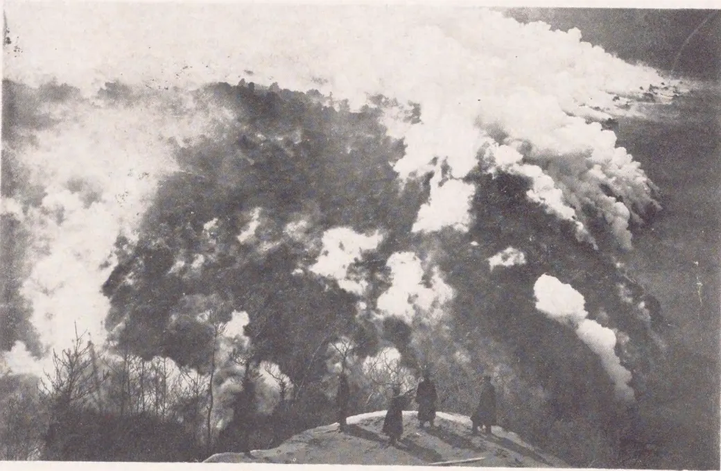
When the molten rock met the ocean on January 16, the clash of fire and water generated apocalyptic steam explosions. Clouds of superheated white vapor surged thousands of feet into the air, boiling the seawater for miles and killing tens of thousands of fish.
Day after day, the lava kept coming. It filled the 240-foot-deep seabed, piled higher than the waterline, and advanced steadily toward the opposite shore of the Ōsumi Peninsula.
By January 29, 1914, the impossible occurred: the lava stream reached the mainland coast. The 1,300-foot-wide marine strait ceased to exist. In its place stood a smoldering, black basalt isthmus over a half-mile wide.
Sakurajima was an island no more. In a matter of days, the volcano had literally welded itself to Kyushu’s Ōsumi Peninsula, transforming into a permanent peninsula.
The Kurokami Torii Gate and the Geological Legacy
When the eruption finally ceased in early spring 1914, the statistics of the catastrophe were staggering:
- The volcano had discharged an estimated three billion metric tons of lava and ash—roughly 1.5 cubic kilometers of volcanic rock.
- The sea floor across Kagoshima Bay sank by up to six feet as the underlying Aira caldera collapsed inward.
- Despite the immense magnitude of the cataclysm, only 58 people died (35 from the earthquake and 23 from volcanic fallout)—an astonishingly low toll made possible entirely by the islanders’ swift self-evacuation.
In the village of Kurokami on the eastern shore, a poignant monument to the eruption survives to this day. The village’s revered Shinto shrine was completely buried under ten feet of volcanic ash and pumice. Only the top crossbar of its massive 10-foot-tall stone Torii gate remains visible above the ground—preserved intentionally by the citizens of Kagoshima as a permanent, humbling reminder of the day the earth rearranged the geography of Japan.
The 1914 eruption of Sakurajima fundamentally reshaped modern volcanology, demonstrating that nature can erase marine channels, redraw national maps, and rewrite the physical borders of our world overnight.
What the Record Shows
8 sourced claims in this story, resting on 4 primary and historical geological records. Numbers link to the bibliography below.
- Earthquakes shook Sakurajima and Kagoshima Bay for two days prior to the January 12 eruption - sources: 1, 2
- Over 20,000 residents successfully evacuated by boat prior to the main explosive phase - sources: 1, 3
- The eruption began on the western flank at 10:05 AM and ruptured the eastern flank ten minutes later - sources: 1, 2
- A powerful magnitude 7.0 earthquake struck that evening at 6:29 PM, killing 35 people in Kagoshima City - sources: 2, 3
- An estimated 3 billion tons (1.5 cubic km) of lava flowed from the craters into the Seto Strait - sources: 2, 4
- The lava completely filled the 1,300-foot-wide marine strait, permanently connecting the island to the Osumi Peninsula - sources: 2, 3
- The total death toll of the combined eruption and earthquake was 58 individuals - sources: 1, 3
- The Kurokami Torii gate was buried up to its top crossbar and remains preserved as a historical marker - sources: 2, 3
Archival Evidence & Picture Credits
- Scene 1: The colossal Plinian ash column on January 12, 1914 - National Science Museum of Japan, Public domain (source)
- Scene 2: The western flank rupture viewed from Kagoshima at 10:12 AM - Kagoshima City Museum, Public domain (source)
- Scene 3: Ash cloud expanding over Kagoshima at 10:50 AM - National Diet Library, Public domain (source)
- Scene 4: Total sky blackout over Kagoshima Bay at 11:00 AM - Kagoshima City Archives, Public domain (source)
- Scene 5: Nabeyama crater vents discharging lava - Geological Survey of Japan, Public domain (source)
- Scene 6: Lava fields cooling at Hakamagoshi - Geological Survey of Japan, Public domain (source)


Verified Archival Sources & Bibliography
Every claim in this account has been fact-checked against primary geological archives and peer-reviewed volcanology literature:
- Japan Meteorological Agency: National Catalogue of the Active Volcanoes of Japan - Sakurajima (primary meteorological archive)
- Geological Survey of Japan (AIST): Sakurajima historical eruptions and the 1914 Taisho flow (primary geological survey)
- Wikipedia: Sakurajima (1914 Taisho Eruption) (reference)
- The Guardian: New data points to major eruption of Japanese volcano (2016 retrospective on 1914 volumes) (scientific news report)
Echoes of History Uncut. "Earthquakes Shook This Volcano Island for Days. Then It Joined the Mainland.." Echoes of History Uncut. Last modified September 22, 2026. https://echoesofhistoryuncut.com/articles/sakurajima-volcano-eruption-1914/.

An independent history publication using AI-assisted research, drafting and production. Consult each article’s citations and limitations; source inclusion does not establish independent verification of every claim.
▶
Watch the Complete Archival Documentary on YouTube
Subscribe to Echoes of History Uncut on YouTube for full widescreen 16:9 documentaries, primary archival footage, and declassified deep dives.